
General Information
- See general fishing regulations for more information on how to use this summary.
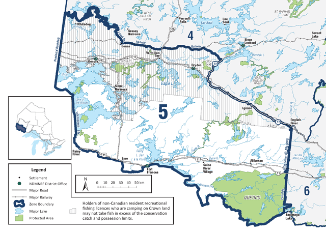
- Non-Canadian residents camping on Crown land must follow conservation fishing licence limits within shaded area on map. Also see regulations for non-Canadian resident anglers in Zone 5.
- Rainbow smelt may not be used as bait or possessed for use as bait.
- The following waterbodies, or portions of them, have different regulations that are listed in the waterbody exceptions:
- Dinorwic Lake (including Minnehaha Lake, Rock Lake and Turtlepond Lake)
- Dryberry Lake
- Eagle Lake
- Experimental Lakes Area
- Kakagi Lake
- Lake of the Woods
- Quetico Provincial Park
- Rainy Lake
- Rainy River
- Seine River System
- Shoal Lake
- Wabigoon River (including Butler Lake, Larson Lake, Mile Lake, Olsen Lake, Paulson Lake and Trap Lake)
- Winnipeg River System
- The following species are not present in this Zone and are closed to fishing all year:
- Atlantic salmon
- brown trout
- channel catfish
- Pacific salmon
- FMZ 5 is part of the Northwest Bait Management Zone (BMZ). Baitfish or leeches, whether live or dead, may not be transported into or out of a BMZ. See bait for more details.
Zone-wide seasons and limits
Zone-wide seasons and limits apply to all waters in the Zone except for the specific waters and species listed in the species exceptions, waterbody exceptions and fish sanctuaries.
Aggregate limits for trout and salmon (including splake)
Limits: S-5 and C-2; total daily catch and possession limit for all trout and salmon species combined
| Species | Season | Limit |
| Brook Trout | All Year | S-5 and C-2 |
| Crappie | All Year | S-10 and C-5 |
| Lake Sturgeon | Closed | – |
| Lake Trout | Jan 1 to Sept 30 | S-2; not more than one greater than 56 centimetres from September 1 to September 30, and C-1; no size limit |
| Lake Whitefish | All Year | S-12 and C-6 |
| Largemouth and smallmouth bass combined | All Year | S-4 and C-2; must be less than 35 centimetres from January 1 to June 30 |
| Muskellunge | Third Saturday in June to Dec 15 | S-1; must be greater than 102 centimetres and C-0 |
| Northern Pike | All Year | S-4 and C-2; none greater than 75 centimetres |
| Rainbow Trout | All Year | S-5 and C-2 |
| Splake | All Year | S-5 and C-2 |
| Sunfish | All Year | S-50 and C-25 |
| Walleye and Sauger combined | Jan 1 to Apr 14 third Saturday in May to Dec 31 | S-4 and C-2; not more than one greater than 46 centimetres |
| Yellow Perch | All year | S-50 and C-25 |
Regulations for non-Canadian resident anglers in Zone 5
- No person who is engaged in recreational fishing from a vessel shall possess more fish on board the vessel than the daily limit for that species.
- Non-Canadian residents must also refer to and follow all species and waterbody exceptions, bait restrictions and fish sanctuaries.
- Non-Canadian residents must follow conservation fishing licence limits when camping on Crown land in portions of Zone 5, see general information and Zone 5 Map for details (PDF).
Walleye and sauger combined
Rainy Lake – includes that portion of the Seine River system upstream to the Sturgeon Falls (Crilly) Dam and the Rainy River from Rainy Lake downstream to the Fort Frances Dam
- Season: January 1 to April 14 and third Saturday in May to December 31
- Daily catch and retain limit – S-1 and C-1; walleye must be between 35-45 centimetres or greater than 70 centimetres, and sauger any size
- Possession limit – S-4 and C-2; walleye must be between 35-45 centimetres or greater than 70 centimetres, only one greater than 70 centimetres, and sauger any size
Rainy River – from dam in Fort Frances downstream to Wheeler’s Point at Lake of the Woods
- Season: January 1 to April 14 and third Saturday in May to December 31
- Daily catch and retain limit – S-2 and C-2; only one greater than 46 centimetres
- Possession limit – January 1 to the last day in February and third Saturday in May to December 31 – S-4 and C-2; only one greater than 46 centimetres
- Possession limit – March 1 to April 14 – S-2 and C-2; must be less than 46 centimetres (see Zone 5 waterbody exceptions)
Winnipeg River System – from outflow of Lake of the Woods to the Manitoba Border including:
- Big Sand Lake (50°08′ N., 94°38′ W.)
- Eaglenest Lake (50°12′43″N., 95°08′40″W.)
- English River, from the Winnipeg and English Rivers upstream to the Caribou Falls dam
- Gun Lake (49°58′ N., 94°39′ W.)
- Hidden Lake (50°04′52″N., 94°35′48″W.)
- Little Sand Lake (50°03′ N., 94°42′ W.)
- Lost Lake (50°01′ N., 94°39′ W.)
- MacFarlane River to Ena Lake Dam
- Middle Lake (49°46′ N., 94°37′ W.)
- Muriel Lake (49°49′ N., 94°41′ W.)
- Pistol Lake (50°00′ N., 94°43′ W.)
- Roughrock Lake (50°06′ N., 94°46′ W.)
- Swan Lake (50°03′46″N. 94°54′30″W.)
- Tetu Lake (50°10′58″N., 95°02′10″W.)
- Season: January 1 to March 14 and third Saturday in May to December 31
- Daily catch and retain limit – S-2 and C-1; walleye must be between 35-45 centimetres and sauger only one greater than 45 centimetres
- Possession limit – S-2 and C-1; walleye must be between 35-45 centimetres and sauger only one greater than 45 centimetres
All other waters of FMZ 5 – including Lake of the Woods; including Cul de Sac Lake, Obabikon Lake and the waters of the Aulneau and Western Peninsulas, but excludes Shoal Lake
- Season: January 1 to April 14 and third Saturday in May to December 31
- Daily catch and retain limit – S-2 and C-2; only one greater than 46 centimetres
- Possession limit – S-4 and C-2; only one greater than 46 centimetres
Lake trout
All waters in FMZ 5
- Season: January 1 to September 30
- Daily catch and retain limit – S-1 and C-1, no size restrictions
- Possession limit – S-2, only one greater than 56 centimetres from September 1 to September 30, and C-1, no size restrictions
Regulations for all anglers in Zone 5 (Including non-Canadian residents)
Species exceptions
Lake trout
Season: closed all year
- Centre for Northern Forest Ecosystem Research Lakes:
- Lake 20 (49°07′46″N., 92°08′19″W.)
- Lake 26 (49°07′23″N., 92°08′40″W.)
- Lake 39 (49°05′42″N., 92°09′56″W.)
- Lake 42 (49°05′05″N., 92°09′36″W.) (research lakes)
- contact Atikokan District Office for more information
- Seahorse Lake (49°06′03″N., 93°18′03″W.)
Muskellunge
Limits: S-1; must be greater than 122 centimetres and C-0
- Burditt Lake (48°57′13″N., 93°46′43″W.) – Senn Township
- Despair Lake (48°52′31″N., 93°39′34″W.)
- Esox Lake (49°06′02″N., 93°15′54″W.)
- Feather Lake (Quill Lake) – Pipestone Chain (49°00′23″N., 93°42′27″W.)
- Footprint Lake (48°54′01″N., 93°36′30″W.)
- Lower Manitou Lake (49°15′15″N., 92°59′19″W.)
- Manomin Lake (48°52′00″N., 93°43′13″W.) – Fleming Township
- Meggisi Lake (49°17′04″N., 92°34′55″W.)
- Pipestone Lake – Pipestone Chain (49°04′ 60″N., 93°33′00″W.)
- Schistose Lake (49°09′17″N., 93°36′18″W.)
- Slender Lake (49°01′60″N., 93°41′ 56″W.)
- Weld Lake (49°01′39″N., 93°40′ 7″W.)
Limits: S-1; must be greater than 137 centimetres, and C-0
- Rowan Lake (49°19′00″N., 93°33′00″W.)
Waterbody exceptions
Dinorwic Lake (49°37′40″N., 92°33′25″W.) – including Minnehaha Lake (49°31′27″N., 92°38′45″W.) , Rock Lake (49°32′37″N., 92°35′51″W.) and Turtlepond Lake (49°32’43″N., 92°36′46″W.)
- Crappie – S-15 and C-10
- Largemouth and smallmouth bass combined – S-2 and C-1; must be less than 35 centimetres from January 1 to June 30 and December 1 to December 31, S-4 and C-2; no size limit from July 1 to November 30
- Muskellunge – S-1; must be greater than 137 centimetres, and C-0
- Walleye – S-4 and C-2; none between 46-58 centimetres, not more than one greater than 58 centimetres
Dryberry Lake (49°30′ N., 93°50′ W.) – Northwest Bay, Point Bay and Point Lake
- Fish or fish parts may not be used as bait from January 1 to Friday before third Saturday in May
- Only barbless hooks may be used from January 1 to Friday before third Saturday in May
- Lake trout – S-1; in one day, possession limit of 2, not more than one greater than 65 centimetres, and C-1; any size
- Muskellunge – S-1; must be greater than 137 centimetres, and C-0
Eagle Lake (49°42′ N., 93°13′ W.)
- No angling at night for any species
- Lake trout – S-1 and C-1; in one day, possession limit of S-2 and C-1; not more than one greater than 65 centimetres
- Largemouth and smallmouth bass combined – S-2 and C-1; must be less than 35 centimetres from January 1 to June 30 and December 1 to December 31, S-4 and C-2; no size limit from July 1 to November 30
- Muskellunge – S-1; must be greater than 137 centimetres, and C-0
- Northern pike – S-4 and C-2; none between 70-90 centimetres, not more than one greater than 90 centimetres
- Walleye – S-4 and C-2; none between 46-58 centimetres, not more than one greater than 58 centimetres
Eagle Lake – portions of Eagle Lake including Whiteclay Narrows, Brule Narrows, Niven Bay, Bunyon Lake, Godson Creek, Kekekwa Creek, Wawapus Creek, Bear Narrows, Froghead Bay, Rice Bay, Violet Lake, One Mile Rapids, Two Mile Rapids, Meridian Bay
- Fish sanctuary – no fishing from April 1 to May 31
Experimental Lakes Area – Pine Road Area, Dryden District, Lakes 111, 189, 191, 221, 222, 223, 224, 239, 260, 305, 373, 375, 377, 378, 382, 442, 622, 623, 626 and 658
- Closed to angling all year – contact Dryden office for more details
Kakagi Lake (Crow Lake) (49°12′60″N., 93°52′00″W.) – Kenora District
- Largemouth and smallmouth bass – S-0 and C-0; from January 1 to June 30
- Muskellunge – S-1; must be greater than 137 centimetres, and C-0
Lake of the Woods – all portions of Lake of the Woods excluding waters of Clearwater Bay, Deception Bay, Woodchuck Bay, Kendall Inlet, Echo Bay, Cul de Sac Lake and Whitefish Bay consisting of Regina, Snake, Boot, Ghost, Brule, Devils, Atikaminike, Camp, Cloverleaf, Log, Reedy, Willow and Sammons bays, and Knickerbocker, Louis, Cross, and Alfred inlets
- Lake Trout – S-0 and C-0
Lake of the Woods – including waters of the Western Peninsula, Aulneau Peninsula and an unnamed lake at 49°36′ N., 94°51′ W.
- No person who is engaged in sport fishing from a vessel shall possess more fish on board the vessel than the daily limit for that species
- Lake whitefish – S-4 and C-2
- Largemouth and smallmouth bass combined – S-0 and C-0; from January 1 to June 30
- Muskellunge – S-1; must be greater than 137 centimetres, and C-0
- Yellow perch – S-15 and C-10
Lake of the Woods – Sabaskong Bay (49°09′ N., 94°09″W.) – Godson Township, Kenora District
- Fish sanctuary – no fishing from April 1 to June 14
Lake of the Woods – Echo Bay (49°42′ N., 94°48′ W.), Cul de Sac Lake (49°38′ N., 94°50′ W.), Clearwater Bay (49°42′ N. 94°45′ W.), Deception Bay (49°42′ N., 94°48′ W.), Woodchuck Bay (49°41′ N., 94°2′ W.) and Kendall Inlet (49°44′ N., 94°52′ W)
- Fish or fish parts may not be used as bait
- Only barbless hooks may be used and for Lake Trout only one barbless hook may be used
- A sport or conservation fishing licence is not valid for retaining trout taken by angling from these waters unless the holder has been issued a lake trout tag – contact Kenora office for details on lake trout tags
- Lake trout – S-0 and C-0 (except for tag holders); open from third Saturday in May to September 30
Lake of the Woods – Whitefish Bay consisting of Regina, Snake, Boot, Ghost, Brule, Devils, Atikaminike, Camp, Cloverleaf, Log, Reedy, Clipper, Willow and Sammons bays and Knickerbocker, Louis, Cross, Alfred inlets
- Possession and/or use of fish or fish parts as bait is prohibited from January 1 to Friday before third Saturday in May
- Only barbless hooks may be used from January 1 to Friday before the third Saturday in May
- Lake trout – S-1; in one day, possession limit of 2, not more than one greater than 65 centimetres, and C-1; any size
Quetico Provincial Park
- Only artificial lures may be used
- Only barbless hooks may be used
Rainy Lake (48°43′20″N., 93°15′41″W.)
- Largemouth and smallmouth bass combined – S-2 and C-1; must be less than 35 centimetres from January 1 to June 30 and December 1 to December 31, S-4 and C-2; no size limit from July 1 to November 30
- Muskellunge – S-1; must be greater than 122 centimetres, and C-0
- Northern pike – S-4 and C-2; none between 70-90 centimetres, not more than one greater than 90 centimetres
- Walleye – S-4 and C-2; must be between 35-45 centimetres or greater than 70 centimetres and not more than one greater than 70 centimetres
Rainy Lake – Squirrel Falls between Namakan Lake and Rainy Lake, downstream for 250 metres on the north shore and 200 metres on the south shore from the Canadian Kettle Falls Dam
- Fish sanctuary – closed all year
Rainy Lake Stanjikoming Bay, Big Canoe River (48°48′ N., 93°13′ W.), Falls River and Pipestone River from Stokes Bay of Rainy Lake upstream to first rapids, Little Canoe River (48°54′ N., 93°18′ W.), Crooked Narrows to Sand Island Falls of Redgut Bay, Halfway Inlet and Lost Bay, Porter Inlet of Redgut Bay, Rat River Bay from the narrows and small island at the entrance to Rat River Bay, upstream to, and including the first rapids of both the West Branch Rat River and the East Branch Rat River
- Fish sanctuary – no fishing from April 1 to June 14
Rainy River – from dam in Fort Frances downstream to Wheeler’s Point at Lake of the Woods
- Lake whitefish – S-4 and C-2
- Largemouth and smallmouth bass combined – S-0 and C-0; from January 1 to June 30
- Muskellunge – S-1; must be greater than 137 centimetres, and C-0
- Walleye – S-2 and C-2; must be less than 46 centimetres from March 1 to April 14
- Yellow perch – S-15 and C-10
Rainy River – from Rainy Lake downstream to the Fort Frances dam
- Largemouth and smallmouth bass combined – S-2 and C-1; must be less than 35 centimetres from January 1 to June 30 and December 1 to December 31, S-4 and C-2; no size limit from July 1 to November 30
- Muskellunge – S-1; must be greater than 122 centimetres, and C-0
- Northern pike – S-4 and C-2; none between 70-90 centimetres, not more than one greater than 90 centimetres
- Walleye – S-4 and C-2; must be between 35-45 centimetres or greater than 70 centimetres, not more than one greater than 70 centimetres
Seine River System – from Kettle Point of Rainy Lake upstream to Sturgeon Falls Dam (Crilly Dam), situated immediately north of Highway 11, including Little Grassy, Grassy, Shoal, Wild Potato and Partridge Crop Lakes
- Largemouth and smallmouth bass combined – S-2 and C-1; must be less than 35 centimetres from January 1 to June 30 and December 1 to December 31, S-4 and C-2; no size limit from July 1 to November 30
- Muskellunge – S-1; must be greater than 122 centimetres, and C-0
- Northern pike – S-4 and C-2; none between 70-90 centimetres, not more than one greater than 90 centimetres
- Walleye – S-4 and C-2; must be between 35-45 centimetres or greater than 70 centimetres, not more than one greater than 70 centimetres
Shoal Lake above Ash Rapids – Kenora District
- Live baitfish may not be used as bait or possessed for use as bait
- Lake whitefish – S-4 and C-2
- Largemouth and smallmouth bass – S-0 and C-0; from January 1 to June 30
- Muskellunge – S-1; must be greater than 137 centimetres, and C-0
- Walleye – closed all year
- Yellow perch – S-15 and C-10
Wabigoon Lake (49°44′09″N., 92°43′52″W.) – including Butler Lake (49°40′ 24″N., 92°39′02″W.), Larson Lake (49°38′23″N., 92°37′06″W.), Mile Lake (49°40′53″N., 92°46′43″W.), Olsen Lake (49°39′06″N., 92°37′47″W.), Paulson Lake (49°37′26″N., 92°36′54″W.) and Trap Lake (49°39′34″N., 92°47′19″W.)
- Crappie – S-15 and C-10
- Largemouth and smallmouth bass combined – S-2 and C-1; must be less than 35 centimetres from January 1 to June 30 and December 1 to December 31, S-4 and C-2; no size limit from July 1 to November 30
- Muskellunge – S-1; must be greater than 137 centimetres, and C-0
- Walleye – S-4 and C-2; none between 46- 58 centimetres, not more than 1 greater than 58 centimetres
Wabigoon Lake – Zealand Township, 100 metres from Christie Island
- Fish sanctuary – no fishing from April 1 to June 14
Winnipeg River System – from outflow of Lake of the Woods to the Manitoba Border including the waters of Big Sand Lake (50°08′ N., 94°38′ W.), Eaglenest Lake (50°12′43″N., 95°08′40″W.), English River, from the Winnipeg and English Rivers upstream to the Caribou Falls dam, Gun Lake (49°58′ N., 94°39′ W.), Hidden Lake (50°04′52″N., 94°35′48″W.), Little Sand Lake (50°03′ N., 94°42′ W.), Lost Lake (50°01′ N., 94°39′ W.), MacFarlane River to Ena Lake Dam, Middle Lake (49°47′27″N., 94°38′14″W.), Muriel Lake (49°49′ N., 94°41′ W.), Pistol Lake (50°00′ N., 94°43′ W.) and Roughrock Lake (50°06′ N., 94°46′ W.), Swan Lake (50°03′46″N., 94°54′30″W.) and Tetu Lake (50°10′58″N., 95°02′10″W.)
- Lake whitefish – S-4 and C-2
- Largemouth and smallmouth bass combined – S-0 and C-0; from January 1 to June 30
- Muskellunge – S-1; must be greater than 137 centimetres, and C-0
- Walleye and sauger combined – open from January 1 to March 14 and third Saturday in May to December 31
- Walleye and sauger combined – S-4 and C-2; Ontario and Canadian resident limit, S-2 and C-1; Non-Canadian resident limit
- Walleye – must be between 35-45 centimetres
- Sauger not more than one greater than 45 centimetres
- Yellow perch – S-15 and C-10
Winnipeg River (west branch) – from Norman Dam to westerly tip of Tunnel Island, thence in a southwesterly direction to the north-east survey post Lot B, Plan M33 (Part of Location A16)
- Fish sanctuary – no fishing from April 1 to June 14
Bait restrictions
Live fish may not be used as bait or possessed for use as bait
- High Lake (49°42′ N., 95°08′ W.) – Territorial District of Kenora
- Shoal Lake – see waterbody exceptions
Fish or fish parts may not be used as bait
- Dryberry Lake – see waterbody exceptions
- Lake of the Woods – see waterbody exceptions
Fish sanctuaries
No fishing – closed all year
- Grimshaw Lake (48°58′ N., 93°04′ W.)
- Rainy Lake – see waterbody exceptions
No fishing – from January 1 to May 31 and October 1 to December 31
- Lilac Lake (48°17′ N., 92°22′ W.) – between Little Vermilion Lake and Lac la Croix
- Trout Lake (48°17′ N., 92°20′ W.) – between Little Vermilion Lake and Lac la Croix
No fishing – from January 1 to July 31 and September 1 to December 31
- Scattergood Lake (49°17′ N., 92°42′ W.)
No fishing – from February 1 to June 30 and August 1 to December 31
- Crook Lake (49°04′ N., 92°08′ W.)
- Little Grey Trout Lake (49°03′ N., 92°03′ W.)
- Rutter Lake (49°04′ N., 92°12′ W.)
- Secret Lake (49°04′ N., 92°08′ W.)
No fishing – from April 1 to May 31
- Eagle Lake – see waterbody exceptions
- Passover Creek – between the southern end of Meridian Bay of Eagle Lake (49°42′ N., 93°13′ W.) and Chancellor Lake
No fishing – from April 1 to June 14
- Crowrock Lake – upstream from the narrows at 49º00′00″N., 91º43′50″W.
- Ladysmith Creek and Unnamed Creek – Ladysmith Township, between Rugby Lake and the confluence of Ladysmith Creek and the unnamed creek flowing out of Tent Lake
- Lake of the Woods – see waterbody exceptions
- Moose Creek – between Big Moose Lake and Cobble Lake including part of Cobble Lake
- Nugget Creek – Zealand Township, between Hughes Creek and C.P.R. crossing at Wabigoon Lake
- Rainy Lake – see waterbody exceptions
- Rugby Lake (49°57′28″N., 92°57′48″W.) – the northern arm that falls within Ladysmith and Rowell Townships
- Trout River (49°01′ N., 92°53′ W.) – from the falls of Sakwite Lake to Otukamamoan Lake
- Wabigoon Lake – see waterbody exceptions
- Wabigoon River – Satterly Township, Snake Bay Road to the Wabigoon Lake Indian Reserve
- White Otter Lake (49°07′ N., 91°52′ W.)
- Winnipeg River – see waterbody exceptions